
By Justin Head — Whitetail Properties Land Specialist & Missouri Licensed Attorney
This is general educational information, not legal advice about any specific stream, tract, boundary, or dispute.
Short answer: In Missouri the word “navigable” hides two completely different questions, and confusing them is the most common — and most expensive — mistake landowners and floaters make. One question is who owns the streambed (title). The other is whether the public may float and wade through (a public easement). On many Missouri streams — especially interior and Ozark streams outside the Missouri and Mississippi River systems — the adjoining landowner may own the bed and banks, yet the public can still lawfully float and wade the channel of a “floatable” stream if the stream meets Missouri’s public-use floatability test, because Elder v. Delcour recognizes a public-highway easement on such streams even where the bed is private. The dividing line for trespass is roughly the streambed and the area the stream covers at normal stages — the outer edge of the streambed / normal-stages area, often described as the ordinary high-water mark and marked in the field near where permanent vegetation begins. Down in that channel is generally lawful public passage; up on the dry, vegetated bank is private ground. Exactly where that line falls on any given gravel bar is the one thing Missouri courts have never settled — which is why this uncertainty has produced real tragedy.
Run the rivers and back roads of the Missouri Ozarks long enough and the questions start stacking up. Who actually owns the creek running through that 200 acres? Can the public float it? Can a floater climb out and eat lunch on the gravel bar? Can the landowner string a fence across it? If you buy the place, what exactly did you buy — the water, the bed, the bank, the gravel? Almost everyone has an opinion, and most of those opinions are wrong, because Missouri water law is one of the most misunderstood corners of property law in the state.
I work both sides of this — as a land agent who sells rural ground along these rivers and as a licensed Missouri attorney — so I’m going to give you the law as the courts have actually written it, with the citations, and then tell you how it plays out in the field across Franklin, Gasconade, Crawford, Phelps, and Dent Counties. Where the law is genuinely unsettled, I’ll say so plainly, because the honest answer is more useful than a confident wrong one. And there is a lot of confident wrong out there.
Here is how unsettled it can get. In 1971 a county prosecutor asked the Missouri Attorney General a simple question — could people float and fish the Little St. Francis River? The Attorney General’s own office declined to make the call, responding that it was not positioned to determine the status of that particular stream and that the local prosecuting attorney was best placed to make that determination. If the state’s top lawyer won’t tell you whether you can float a specific creek, you can see why this subject needs careful handling. (Mo. Att’y Gen. Op. Ltr. No. 264-71 (June 22, 1971).)
In this guide
- Two meanings of “navigable”
- Who owns the streambed in Missouri?
- Who can float through private property?
- The ordinary high-water mark — and what about gravel bars?
- Is “a canoe can float it” enough?
- What the courts have actually said about our rivers
- County-by-county water notes
- The landowner’s rights and limits
- Wells, drainage, ponds, dams, and liability
- What water means when you buy or sell
- Frequently asked questions
Two questions hide inside one word: “navigable”
Start here, because everything else flows from it. When a Missouri lawyer or judge says a stream is “navigable,” they could mean either of two things, and the two have different tests and different consequences:
- Navigable for title — who owns the dirt under the water. If a river was navigable at statehood (Missouri came into the Union in 1821), the State owns its bed. If it was not, the bed belongs to the landowners on the banks.
- Navigable (or “floatable”) for public use — whether the public has a legal easement to travel the stream by floating and wading, regardless of who owns the bed underneath.
A stream can flunk the first test and pass the second. In fact most of our streams do exactly that: the landowner owns the bed, and the public can still legally float through. Keep those two ideas in separate boxes in your head and Missouri water law suddenly makes sense. Mix them — as most internet explainers do — and you’ll reach the wrong answer almost every time.
Who owns the streambed? (Navigability for title)
For title, Missouri uses the federal test: a river is navigable in law if, in its ordinary condition, it was usable as a highway for commerce by the customary vessels of trade — the boats that actually carried freight and passengers. And Missouri applies that test strictly. As the Supreme Court put it, while some states count log rafting as commerce and broaden the rule, “In Missouri, however, we have held to the more rigid rule, and with some aggressiveness.” (Slovensky v. O’Reilly, 233 S.W. 478, 481 (Mo. 1921).)
So which Missouri rivers are actually navigable for title? The Mississippi and the Missouri are the classic rivers that are clearly navigable for purposes of bed ownership under the Missouri decisions. Beyond those two, Missouri decisions have generally treated the interior and Ozark streams the courts have classified — including the Current, the Black, the Platte, the Gasconade, the Chariton, and the upper reaches of the Meramec — as non-navigable for title, meaning the bed belongs to the bank owners, not the State. (Mo. Att’y Gen. Op. Ltr. No. 264-71 (June 22, 1971), collecting the cases.) But do not turn that into a universal rule. Navigability is decided reach by reach — the lower Meramec in St. Louis County has been treated differently — and title navigability, federal regulatory navigability, and public-use floatability are three separate questions. The practical lesson is the narrow one: outside the two big rivers, and especially on Ozark streams, assume the bed is private unless a deed, survey, controlling case, or other reliable legal authority shows otherwise.
The practical upshot for a landowner: on a non-navigable stream — which includes many interior and Ozark streams — if you own both banks, you own the entire bed, from bank to bank, including the gravel. If you own one bank, you generally own to the center thread of the stream. Even the islands are usually private. You own the rocks and the bed; you do not own the flowing water in the same absolute sense — you hold riparian rights to reasonable use — and the fish remain public resources until lawfully taken. (T.L. Wright Lumber Co. v. Ripley County, 192 S.W. 996 (Mo. 1917); Elder v. Delcour, 269 S.W.2d 17 (Mo. banc 1954).)
Who can float through? The Elder v. Delcour rule
Owning the bed is not the same as controlling who passes over it — and that is where the single most important case in Missouri water law comes in. Fittingly for us, it happened right here.
In Elder v. Delcour, a fisherman named Elder put a canoe in at a public road crossing and floated and fished down the Meramec River — across a farm in Dent County owned by a man named Delcour. Delcour had the place posted and fenced, claimed he owned the river, strung a wire water gap fence across the channel, and ordered Elder to turn around. Elder pressed the fence down, floated over, portaged his canoe around a log jam along the bank, waded and fished, stopped to eat lunch, and floated on out. Then he went to court to settle, once and for all, whether he had a right to be there. The Missouri Supreme Court, sitting en banc, said he did. (Elder v. Delcour, 364 Mo. 835, 269 S.W.2d 17 (Mo. banc 1954).)
The Court first held that this stretch of the Meramec was non-navigable for title — so Delcour, owning both banks, owned the bed. But it then held that the river was nonetheless a public highway the public could travel. Here is the holding, in the Court’s own words:
“…the waters of the Meramec River are public waters and the submerged area of its channel over and across appellant’s farm is a public highway for travel and passage by floating and by wading, for business or for pleasure, and that in traveling the course of the stream by canoe or wading, respondent was not a trespasser on the property of appellant.”
That sentence is the foundation of every float trip in Missouri. On a floatable stream, the public may travel the channel — by boat or on foot in the water — for business or pleasure, and that passage is not a trespass even though a private citizen owns the ground under the water. The right to fish rests on a separate point the same case settled: the fish belong to the State until a licensed angler lawfully catches them, so a floater who is lawfully in the water may lawfully fish.
For landowners, the key is this: ownership of the bed may give you property rights in the gravel and banks, but it does not necessarily give you the right to exclude lawful passage through the channel.
The ordinary high-water mark: where the public’s right ends and trespass begins
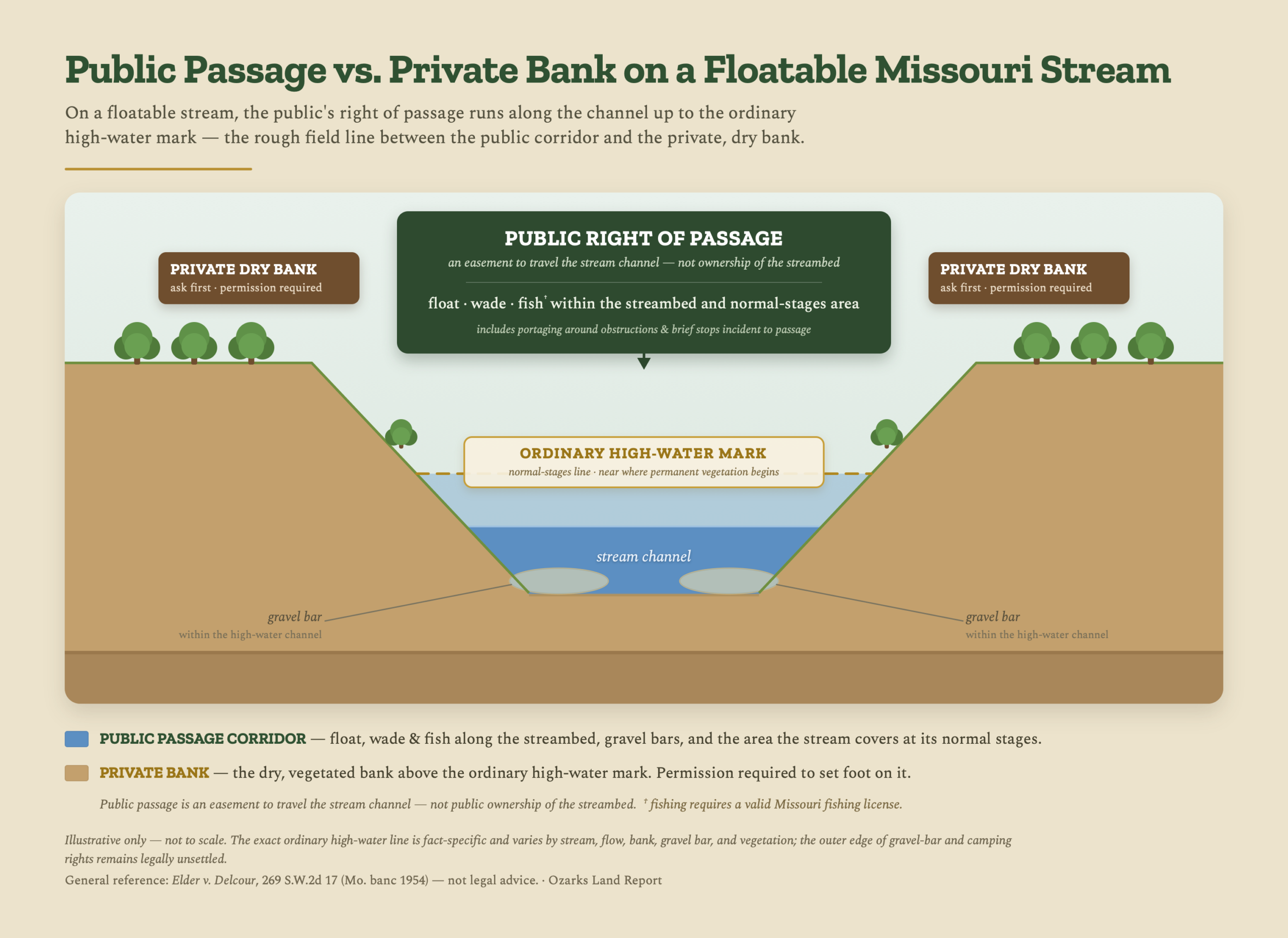
Here is the question that actually gets people into trouble: the float right covers the channel — but how far up the bank does “the channel” reach? Elder answered it in general terms by approving the trial court’s description of what the floater could use. He had the right, the judgment said, to tie up or even camp —
“…as long as he uses the stream bed, gravel bars and clearly recognizable area over which the stream flows during its normal stages.”
People usually describe that boundary as the “ordinary high-water mark,” and the Missouri Department of Conservation uses a workable field version of it — generally the line where trees and other permanent vegetation take hold. That is a useful rule of thumb, but it is a simplification. Elder’s actual standard is more factbound: the streambed, the gravel bars, and the clearly recognizable area the stream covers at its normal stages, including the bars that sit underwater part of the year. The practical takeaway is the same in either framing — down in the bed and the wash of the stream the public may float, wade, fish, and pass; up on the dry, vegetated bank you are on private property and need permission — but that boundary is a rough field line: fact-specific, tied to the normal-stages area, not a surveyed contour.
Notice what Elder did not decide, because it matters. Elder asked for the right to stand on the privately owned banks to fish, and the Court declined to declare any such right — observing that the public has been denied that right in other states. So the rule is narrow and worth memorizing: the float right is a right of passage in the water and the wash of the stream, not a right to occupy the dry bank. Floating by is fine. Climbing out onto the green bank to set up chairs is not.
And here is the hard truth the brochure at the canoe rental won’t tell you: no Missouri court has ever fixed exactly where that high-water line runs on a given gravel bar. Elder approved camping within the normal-stages area, but where the normal-stages gravel ends and the off-limits bank begins is a fact question that changes with every bend in the river. MDC itself acknowledges that opinions about where the high-water marks lie can vary dramatically.
That does not mean every exposed gravel bar is safe to treat as a campsite; the outer edge of the normal-stages area is fact-specific, and local rules, littering laws, nuisance concerns, and law-enforcement judgment still matter.
That ambiguity is not academic. In July 2013, on the Meramec in Crawford County between Cuba and Steelville, a riverfront landowner shot and killed a floater who had stopped on a gravel bar the landowner claimed as his own; the landowner was convicted of second-degree murder and sentenced to 25 years. A dispute over exactly the line this article is about turned fatal — it cost one man his life and the other his freedom. Treat it with respect from both sides of the bank.
Within those limits, what may a floater or angler actually do on a floatable Missouri stream? A fair reading of Elder and the cases it relied on:
- Float and wade the channel through private property, for business or pleasure — not a trespass.
- Fish from the water with a valid Missouri permit.
- Portage around obstructions in the channel where reasonably necessary to continue lawful passage — subject to paying for any damage done and subject to applicable local, safety, and access rules.
- Use the bed and gravel bars within the normal-stages area — including, per Elder, stopping, tying up, and even camping — with the heavy caveat that the outer edge of that area has never been precisely drawn.
And what crosses the line into trespass:
- Going up onto the dry, vegetated bank without the landowner’s permission — even on a public stream.
- Entering a private stream that is not a public-use stream. A stream that does not qualify as a public-use stream carries no public right; fishing, wading, and boating there may constitute trespass without permission.
- Crossing private land to reach the water. The right to float does not include a right to walk across someone’s field to get to the river. Your put-in and take-out must be public property or used with permission. Missouri has no statute granting the public a general right of access to streams or lakes.
Is “a canoe can float it” enough? The nuance everyone gets wrong
You will hear, constantly, that any stream a canoe can float is open to the public. That is not what Missouri law says, and Elder itself warned against the shortcut. Quoting the U.S. Supreme Court, the Elder Court cautioned that navigability is not established by —
“…every small creek in which a fishing skiff or gunning canoe can be made to float at high water… in order to give it the character of a navigable stream, it must be generally and commonly useful to some purpose of trade or agriculture.”
The proof is in Elder’s own conclusion. The Court went out of its way to say its holding did not conflict with an earlier case, Dennig v. Graham, which had kept the public off Greer Spring and its branch as private waters — even though that branch will easily float a canoe. So a stream’s being canoe-floatable is necessary, but not by itself sufficient, to make it a public highway. The historic test asked whether the stream was actually useful for commerce — in the Ozarks, that famously meant floating railroad ties and logs to the mills and railheads. There is genuine tension in the case law here, and you should know it exists: some Missouri language suggests a truly navigable stream must be usable by larger vessels, not merely by canoes. (Tomkins v. Monarch Bldg. Materials, 347 S.W.2d 152 (Mo. 1961).) The line between a public float stream and a private creek is real, and on the small stuff it is genuinely contestable.
Put it simply: canoe-floatability is a strong practical indicator and the way people talk about it in the field, but the public’s right does not arise merely because someone can scrape a canoe through at high water — its legal source is that older public-highway, commercial-use doctrine the courts applied in cases like Elder.
MDC summarizes the practical field rule this way — a workable three-bucket field guide:
- Public, navigable — big rivers a barge could use. Property lines stop at the high-water mark; the area between the marks is public.
- Public, non-navigable — mid-sized, canoe-floatable streams. The landowner owns the bed, but the public may float, wade, and fish within the streambed.
- Private, non-navigable — streams too small to float a canoe. No public right at all; you need permission.
That is a useful rule of thumb — but a rule of thumb, not a final title opinion. Think of this as an agency field guide, not a final title opinion or a court ruling on any particular reach. The safe practical point: do not treat a public-access brochure as a deed, survey, or title opinion.
What a court has actually said about our rivers
Most of what passes for “the law” on a particular creek is really just local custom. But for a handful of our region’s signature streams, a Missouri appellate court genuinely has ruled — and those rulings are the rare bedrock in a fact-dependent area.
- The Meramec — three different answers by reach. Held non-navigable for title in Crawford County (Slovensky, 1921); held a public floatable highway in Dent County (Elder, 1954); and treated as possibly title-navigable in its lower St. Louis County reach (Tomkins, 1961). Same river, three legal characters depending on where you stand on it. That is the single best illustration in Missouri law that navigability is decided stretch by stretch.
- The Gasconade — on both lists at once. In Hobart-Lee Tie Co. v. Grabner (1920), the Gasconade in its Pulaski County reach was held non-navigable for title yet navigable, or floatable, as a public highway for floating ties — but the court also held that hauling those ties out across the privately owned bank and gravel bar was an ongoing trespass. One case, proving a stream can be private-bedded and public-to-float at the same time.
- The Current River — public to float. Non-navigable for title near Doniphan (T.L. Wright, 1917) but recognized as a public floatable stream (State v. Wright, 1919). Its headwaters rise at Montauk in Dent County.
- Indian Creek — a court-confirmed public highway in our backyard. The Meramec tributary Indian Creek, in Washington and Franklin Counties, was held a public highway for floating railroad ties in McKinney v. Northcutt (1905) — and Elder cited it with approval.
Now the essential caveat: most of our creeks have never been ruled on. I am not aware of a reported Missouri appellate decision classifying the Huzzah, the Courtois, the Bourbeuse, Big Berger, the Little Piney, Dry Fork, or the dozens of headwater branches. For those, the MDC three-bucket guide and local custom are your practical guide — not settled law. Anyone who gives you a definitive yes-or-no on an unruled creek is guessing.
Need an answer for a specific property? Request a free, no-obligation land valuation.
County by county: the streams under our feet
With all of that as the legal backdrop, here is the practical lay of the water across the five counties we work. Treat the legal notes as “a court has held” only where I say so; everything else is geography and recreation, not adjudication.
Franklin County
The Franklin County water story runs from the Missouri River along the north (title-navigable, a boundary water more than a float stream) to two classic float rivers: the Meramec, which divides into its upper and lower runs near the Bourbeuse confluence by Union, and the slow, deeply meandering Bourbeuse itself. And the county holds a genuine legal landmark — Indian Creek, the Meramec tributary a court actually held to be a public floatable highway. Good creek frontage here is an amenity buyers pay for; just know what comes with it.
Gasconade County
The Gasconade County namesake is the Gasconade River — the longest river running entirely within Missouri, a long, remote, gravel-bar float that empties into the Missouri near Hermann. The Bourbeuse crosses the county too, and Big Berger and Frene Creeks drain the uplands. The Gasconade’s legal character was litigated upstream in Pulaski County (Hobart-Lee), the case that proves a stream can be private-bedded and public-to-float at once.
Crawford County
If you want the postcard Ozark float, Crawford County is it: the upper Meramec around Steelville, fed by two of the most-loved spring tributaries in the state, Huzzah Creek and Courtois Creek (“Coat-a-way” to the locals). Dry Fork crosses in from the west with trout water in it. The Meramec here is the stream held non-navigable for title back in 1921 — and the river between Cuba and Steelville is where the 2013 gravel-bar tragedy happened, a permanent reminder of how real the high-water-mark question is.
Phelps County
The Phelps County waters trend cold and clear: the Gasconade flows through, the Big Piney clips the western edge (it is mostly a Pulaski and Texas County river), and the Little Piney is a small, spring-fed Blue Ribbon trout stream floatable only on its lower reaches. Mill Creek, Spring Creek, and Dry Fork round out a county better known for trout than for big floats.
Dent County
The Dent County claim to fame is twofold. It is the headwaters county — the Meramec rises here above Short Bend (the very upper reaches are a losing stream and often dry, not floatable until farther down), and the Current River springs to life at Montauk State Park, one of the great trout parks in America, before becoming the Current of float-trip legend downstream. And Dent County is hallowed ground for this whole subject: Elder v. Delcour, the case that cemented Missouri’s modern recreational right to float, arose on the Meramec right here.
The landowner’s side: what you can’t do, even though you own the bed
If you own the streambed, it is tempting to think you control the river. You don’t — and Elder spelled out the limits. Even as the owner of the bed, a Missouri landowner may not:
- Block the public’s passage on a floatable stream. Delcour’s wire fence across the Meramec is the textbook example of what does not work — a landowner should not maintain a fence, wire, water gap, or other obstruction in a way that blocks or endangers the public’s lawful passage on a floatable stream.
- Obstruct, divert, impound, or accelerate water in a way that unreasonably harms another landowner — that can create civil liability and, in some settings, regulatory or criminal issues.
- Resort to self-help that escalates the situation. Even when someone has crossed onto your dry bank, self-help can hand you a brand-new liability problem. If someone is genuinely trespassing, the safer move is to call law enforcement or pursue it civilly — not to damage property, create a hazard, or force a confrontation.
- Divert the stream into a private lake to the exclusion of downstream owners.
- Build, fill, dredge, dam, or obstruct a watercourse without checking the whole permitting picture. You cannot obstruct the free passage of fish, and Missouri’s dam-safety law is only one layer. Depending on the project, federal Clean Water Act and Army Corps rules, state water-quality certification, stormwater and land-disturbance rules, floodplain regulations, county or municipal requirements, recorded easements, and downstream owners’ claims can all come into play. Check before you move dirt or water.
What you can control is the dry bank — and that is where posting comes in. On a private-bed float stream, the bank above the ordinary high-water mark is private, and a floater who climbs out onto it without permission is trespassing. Proper posting (including Missouri’s purple-paint marks) — or telling the person directly — supplies the notice that turns that into enforceable first-degree trespass under the criminal-trespass statute. Posting your bank does not, however, give you any power to stop lawful passage down the water itself.
Beyond floating: the rest of Missouri water law every landowner should know
Floating rights get the headlines, but the questions that actually land on my desk are just as often about wells, drainage, ponds, and boundaries. Here is the rest of the map, in brief.
Using the water: riparian “reasonable use”
Missouri is a riparian-rights state, not a western “first in time” state. Every landowner whose ground touches or lies over a water source has a right to make reasonable use of it, measured against the equal rights of the others who share it. There is no general state permit that allocates how much an ordinary landowner may withdraw simply because the land touches a stream, lake, pond, well, or spring. The one statewide quantity rule most landowners should know is registration: if you have equipment capable of withdrawing or diverting 100,000 gallons a day or more — roughly 70 gallons a minute — from any stream, river, lake, well, spring, or other water source, you must register as a Major Water User with the Department of Natural Resources and file annual reports. (§§ 256.400–256.410, RSMo.)
Groundwater and wells
Missouri follows a “reasonable use” rule for groundwater too. You don’t “own” the water under your land in an absolute sense; you have the right to use it in connection with the beneficial enjoyment of that land. Pumping groundwater and piping it off the tract in a way that harms your neighbors’ wells can be actionable. (Higday v. Nickolaus, 469 S.W.2d 859 (Mo. App. 1971).)
Surface water and drainage fights between neighbors
This is one of the most common rural disputes there is, and the rule changed in 1993. For over a century Missouri followed the “common enemy” doctrine, which let a landowner fend off surface water with near-impunity. The Supreme Court threw that out and adopted a rule of reasonable use: you may grade, fill, build, and alter how water runs off your land, but you become liable if your interference with the natural flow is unreasonable and harms your neighbor — whether you did it on purpose or by careless mistake. (Heins Implement Co. v. Missouri Highway & Transportation Commission, 859 S.W.2d 681 (Mo. banc 1993).)
When the river moves the line: accretion, reliction, avulsion
Where a stream is the boundary, moving water can move your property line — but only sometimes. If the channel shifts gradually and imperceptibly (accretion building land, or reliction uncovering it), the boundary moves with the stream, and the new ground belongs to the adjoining owner. If the channel jumps suddenly — an avulsion, like a flood cutting a new course overnight — the boundary stays put at the old channel line, even if no water flows there anymore. This is why a riverfront survey and the deed’s description deserve a hard look before you buy bottom ground.
Dams, ponds, and lakes
Missouri’s dam-safety program (Chapter 236) uses technical statutory definitions and exemptions — including height, reservoir, agricultural, and federal-license issues — so ordinary farm ponds often fall outside the main permitting machinery, but the only safe answer is to check Chapter 236 and DNR before building, enlarging, or altering a dam. “Outside the dam-safety program” does not mean “no rules apply.” A smaller pond or stream impoundment can still run into federal Clean Water Act and Corps permitting, state water-quality certification, stormwater and floodplain rules, county or municipal requirements, easements, and downstream owners’ rights. And one trap worth flagging on shared and subdivision lakes: Missouri courts hold that riparian rights do not attach to artificial bodies of water. Owning a lot that touches a man-made lake gives you no automatic right to use the whole surface — your right to boat, fish, or build a dock comes only from owning the lakebed, an easement, or a recorded contract or indenture. (Incline Village Board of Trustees v. Edler, 592 S.W.3d 334 (Mo. banc 2019).) If you’re buying into a lake community, read the indenture before you assume you can put in a dock.
Ponds and dams turn out to be their own subject, and a deep one. The 35-foot line in Chapter 236 is measured from the crest down to the lowest point on the downstream toe, not the depth of the water you see — and for most creek dams the federal question matters more than the state one. The full treatment is here: Missouri Pond and Dam Law: Can I Dam the Creek and Build a Pond on My Land?
Your liability to people on the water
Two Missouri statutes shield landowners along the water, and both are useful, but neither is a blank check. The Recreational Use Act (§§ 537.345–537.348) says that if you let people use your land or water for recreation without charging them, you owe them no duty to keep it safe and no duty to warn — and that protection expressly covers ponds, lakes, and dams. But that protection has real limits: it can fall away where entry is charged, where there is a malicious — or grossly negligent — failure to guard or warn against a known dangerous condition, or where the injury involves certain known ultrahazardous conditions. Separately, § 258.200 immunizes a landowner along a stream from liability to someone who enters from the river and is hurt — unless the injury is caused by the owner’s own intentional, unlawful, negligent, willful, or wanton act.
How all of this shows up when you’re buying or selling
A creek or river through a tract is a genuine amenity buyers will pay up for: frontage, fishing, a float in the backyard, cold-water trout, wildlife. But the same water raises questions a good agent and a careful buyer work through before, not after, the contract:
- Is the stream floatable, and what comes with that? On a public float stream you’re buying ground the public can legally pass through in the channel — usually a non-issue, occasionally a privacy consideration on a popular run. Know which you’ve got.
- Is the water a boundary — and has it moved? If a creek is the property line, accretion and avulsion may have shifted things since the last survey. Get the line confirmed on riverfront and bottom ground.
- How do you actually reach the water — and the back of the place? Public access versus crossing someone else’s ground is the single most common rural deal-killer — the same access analysis I walk through in our guide to checking legal access before you buy.
- Shared ponds and lakes need paperwork. On a man-made lake, confirm your surface rights come from the deed, an easement, or the indenture — not just from touching the water.
Waterfront Land Due Diligence Checklist
- Confirm legal access to the water (public access or a recorded easement — not crossing a neighbor).
- Determine whether the stream is public-use floatable, and what that means for privacy and use.
- Review the survey and deed language if the stream is a boundary (watch for accretion and avulsion).
- Check for floodplain, Army Corps, DNR, dam-safety, pond, and drainage issues before you build or dredge.
- Confirm your rights on any shared or artificial lake from the deed, easement, or indenture.
- Understand whether public float traffic affects the property’s privacy or value.
The bottom line for Missouri landowners
Water is often the best thing about a piece of Ozark ground and the most misunderstood thing about it. The framework is actually learnable: first ask whether a stream is navigable for title — a narrow question under Missouri law, with the Missouri and Mississippi Rivers as the classic, clearly title-navigable examples — and then ask the separate question of whether it is floatable for public use. Keep the ordinary high-water mark in mind as the rough line between public passage and the private bank, and respect that the exact edge of that line is unsettled enough that it deserves caution and courtesy from floaters and landowners alike. The goal is not to win an argument on the gravel bar; the goal is to understand the risk before the argument starts. For the float trips themselves, our favorite Ozark floats run right through this country.
Frequently asked questions
Can the public float through private property in Missouri?
Yes — on a stream that qualifies as a public-use “floatable” stream. Under Elder v. Delcour, the public may float, wade, and fish within the channel even where a private landowner owns the bed, but only in the water and the wash of the stream, not up on the dry bank.
Who owns the creek bed in Missouri?
On most Missouri streams — outside the Missouri and Mississippi Rivers and any other reach shown by controlling authority to be title-navigable — the bed is private. If you own both banks, and the deed or survey does not say otherwise, you generally own the whole bed bank to bank, including the gravel; if you own one bank, you typically own to the center thread.
Can floaters stand on gravel bars in Missouri?
Within the streambed and the gravel bars in the area the stream covers at its normal stages, generally yes — Elder even approved stopping and camping there. But no court has fixed the outer edge of that normal-stages area, so gravel bars up near the dry bank are legally risky and should be treated with caution.
Can a Missouri landowner fence off a creek?
Not in a way that blocks or endangers lawful public passage on a floatable stream — that was the exact wire water-gap fence struck down in Elder. Reasonable agricultural fencing and water gaps are common, but they cannot be used to shut the public out of a floatable channel.
Is every creek that can float a canoe public?
No. Canoe-floatability is a strong practical indicator but not the legal test; the public right traces to an older public-highway, commercial-use doctrine, and Missouri courts have kept the public off some canoe-floatable waters (for example, the Greer Spring branch in Dennig v. Graham).
Where is the high-water mark on a Missouri stream?
Roughly the line the stream reaches at its normal stages — often described in the field as where permanent vegetation begins. The precise ordinary high-water line is a fact question that varies by stream, flow, bank, and gravel bar, and Missouri courts have never fixed it on any given bar.
Official resources worth checking
- Elder v. Delcour, 269 S.W.2d 17 (Mo. banc 1954) — the controlling public-float case.
- Missouri Department of Conservation — stream access & trespassing.
- Missouri DNR — Major Water User registration (statute: §§ 256.400–256.410, RSMo).
- Missouri DNR — Dam and Reservoir Safety Program (statute: Chapter 236, RSMo).
- Recreational Use Act, §§ 537.345–537.348, RSMo — landowner protection for free recreational use.
- § 258.200, RSMo — landowner liability along streams.
- Missouri Attorney General Opinion Letter No. 264-71 (June 22, 1971).
- U.S. Army Corps of Engineers — district navigable-waters / Section 10 lists.
If you’re buying or selling land along a creek or river in Franklin, Gasconade, Crawford, Phelps, or Dent County and want a straight read on what the water means for value, boundaries, access, and liability, that is squarely what we do — as landowners on these rivers ourselves and with the legal background to back it up. Call Justin at (573) 308-7376 or Ryan at (573) 259-6360, or request a free land valuation.
This article is general educational information about Missouri law as of its writing, not legal advice, and it does not create an attorney-client relationship. Water law is unusually fact-dependent: the classification of any particular stream, boundary, or dispute turns on its own facts and can change with new decisions. Before relying on the public’s right to float a specific stream — or before acting to restrict it — consult a Missouri attorney, and check a specific stream’s status with the local prosecuting attorney and the Missouri Department of Conservation.
Related: for what bare land is actually selling for in this region, see the Bare Dirt Report county editions — closed-sale medians by year, price zones, tract sizes, and time to contract: Franklin County, Gasconade County, Crawford County, Phelps County, and Dent County.
Justin Head is a land specialist with Whitetail Properties and a licensed Missouri attorney. He works with buyers and sellers of farms, hunting land, timber, and recreational property across Franklin, Gasconade, Crawford, Phelps, and Dent Counties, with a focus on the legal, practical, and market issues that shape rural land ownership in Missouri.